Minimizing sediment arrival to reservoir
Contents
Introduction
Natural variations in sediment concentration occur over days, weeks, seasons and years. They are induced by land erosion resulting from high flows from rain fall or snow melting. These variations are generally handled by ecosystems if they do not change dramatically hydro-morphological conditions in rivers over long periods. However extreme concentrations of sediments related to anthropogenic causes (mining, building of roads, spilling water from dams, permafrost melting due to climate change, use of pesticides in agriculture, economy of cultures as plants for biofuel, etc.) or natural events (flood, volcanic eruptions) might affect significantly physical conditions and habitats for fish. Extreme sediments levels can also occur in rivers where hydropower regulation has introduced dramatic reduction of discharge levels compare to the natural flow conditions.
High levels of fine sediments induce a lack of water clarity, called turbidity, which might impact fish's feeding and growth, cover and risk of predation, displacements, egg survivals, or food abundance. Additionally, changes in water quality and chemistry might even more degrade habitat conditions as chemicals adhere to fine sediments. In some cases, mitigations measures to reduce the amount of sediments in water can be implemented to improve fish habitat quality. Measures consisting in reducing the amount of sediments entering the reservoir have been primarily developed to address loss of reservoir capacity and avoid the flow of fine sediments through turbines. If carefully applied, these
Methods, tools, and devices
During planning
Erosion control in catchment aims at reducing sediment yield to rivers and reservoirs affected by land-use change in the surrounding catchment. It can be realized through reforestation, contour farming in agriculture (planting across slope and following elevation lines), and land stripe planting along rivers. The aim is to induce sediment deposition where vegetation is planted.
It requires agronomist knowledge to develop a design plan (selection the most suitable plants, determination of the best combination of vegetation, assess vegetation planting density, etc.)
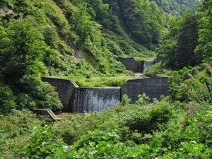
Check dams are small dams constructed across waterways that locally slow down the flow velocity and reduce the channel gradient. Consequently, they reduce erosion in the river channel and induce both debris and sediment deposits. The design of check dams requires a good knowledge of both the spatial and temporal variability of river hydraulics and the catchment sediment yield to the river.
Sediments traps are low dams constructed in watercourse where sediments settle. They can be installed where sediments tend to accumulate. The design of the sediment trap depends on the flow velocity and the particles sizes. Sediments traps should be designed for an easy removal of accumulated sediments.
During the planning phase, scenarios of implementation of the different measures can be simulated to estimate the impacts of the measures on sediment yield reduction. Numerical model, integrating land-use and structure can be applied to the selected catchment. RUSLE and SWAT models (see Chapter 9.1 for reference) are among them.
During implementation
Planting of vegetation should follow a specific planning and be followed up by agronomists. Reforestation is a mitigation measure with mid and long-term effect as soil strength and vegetation cover can require months to years to develop the required condition for controlling erosion. It might require regular watering in semi-arid and arid areas during the implementation phase.
During operation
Check dams require maintenance and surveillance. In river basins with high sediment yield, check dams can be quickly filled with sediments. Sediments needs to be regularly excavated to preserve its functionality and avoid risk of instability.
Sediment traps require regular maintenance to preserve their functionality. Heavy equipment is necessary to excavated sediments out of the traps.
Control of the areas where erosion control has been introduced should be carried out regularly to check the effective percentage cover and assess the effectiveness of the measure against erosion.
