Shelter measurements
Contents
Quick summary
Developed by: Laboratory of hydraulics, hydrology and glaciology (VAW) of ETH Zurich
Date: May 2018 (Version 2.8)
Type: Method
Suitable for the following [[::Category:Measures|measures]]:
Introduction
The technique was developed by Finstad to estimate the shelter availability for juvenile salmon (Finstad et al. 2007a). In this stage of their life cycle, the salmon seeks shelter in the free spaces of the upper layers of the river bed sediment (Figure 1). The existence and size of such openings to be used as shelter is measured with the described technique. It is relatively easy to be carried out in the field. The method is based on the idea to mimic the small fish by using a plastic tube which has the approximate diameter of such a fish.
For salmon Finstad used tubes with five different diameters (5, 10, 13, 16, 22 mm). As a result of their experiments Forseth et al. (2014) suggest the use of a 13mm tube to conduct the tests in an area of about 0.25m2. The tube is marked according to the three different shelter categories at lengths of 2, 5 and 10 cm to be able to detect certain possible hiding depths. Within the fixed framed area one is aiming to find every hole or opening where one can stick the tube into. The length of the tube (defined by the three rings) which is not visible any more, defines the potential hiding depth (Figure 2).
The post-processing of the data is quite simple and described in the following section.
In FIThydro this technique shall be applied also to other fish species than the salmon. Therefore we use in addition tubes with diameters of 5 mm and 8 mm. These results can then be linked to the D5 and D10 grain diameter of the sediment (Szabo-Meszaros et al 2016).
The method was developed in and for Norwegian rivers with large grain sizes. It is currently (also in FIThydro) under investigation if, when using it in rivers with a smaller D50, i.e. smaller grain sizes, this relation still applies or another relation becomes relevant.
Application
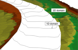
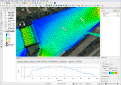
The 1D model of BASEMENT is based on river cross sections and its main application are river reaches where the level of detail is less important. The 2D model uses a triangular computational grid to reproduce the topography and can be applied to more detailed and complex problems than the 1D model, e.g. the inundation or river bar formation. BASEMENT supports Windows as well as Linux platforms and includes a graphical user interface (GUI) which supports the user during the model setup and simulation process (Figure 2). For grid generation, the QGIS plugin BASEmesh is provided by the developers and for visualization of the results, among others, the QGIS plugin Crayfish (QGIS 2.8) from Lutra Consulting (https://www.lutraconsulting.co.uk) can be used (Figure 3).
Other information
In addition to the use on regular Windows and Linux workstations, the upcoming version 3.0 of BASEMENT (March 2019) is designed to run on graphical processing units (GPUs) and distributed memory computer clusters allowing engineers to tackle problems with very large computational domains or long simulation time.
Relevant literature
- Vetsch D., Siviglia A., Caponi F., Ehrbar D., Gerke E., Kammerer S., Koch A., Peter S., Vanzo D., Vonwiller L., Facchini M., Gerber M., Volz C., Farshi D., Mueller R., Rousselot P., Veprek R., Faeh R. 2018. System Manuals of BASEMENT, Version 2.8. Laboratory of Hydraulics, Glaciology and Hydrology (VAW). ETH Zurich. Available from http://www.basement.ethz.ch.
Contact information
Website (download, tutorials, etc.): http://www.basement.ethz.ch
Email: basement@ethz.ch


