River2D
Contents
Quick summary
Developed by: Freshwater Institute in Winnipeg, Civil and Environmental Department of the University of Alberta in Edmonton, Midcontinent Ecological Science Center of the U.S. Geological Survey in Ft. Collins, and Fisheries Division of the Alberta Government in Cochrane.
Date: 2002
Type: Tool
Introduction
The River 2D is a two dimensional depth-averaged finite element hydrodynamic model that has been customized for fish habitat evaluation studies (Steffler, 2000). The River2D model simulates hydraulic conditions in natural rivers from topographic data input, and uses the habitat suitability curves containing known biological preference data, to calculate the potential habitat for specific species life-history stages by obtaining the Weighted Usable Area (WUA).
The model suite consists of four programs: R2D_Bed, R2D_Ice, R2D_Mesh and River2D (Figure 1). R2D_Bed was designed for editing bed topography data while R2D_Ice is intended for developing ice topographies to be used in the modelling of ice-covered domains. The R2D_Mesh program is used for the development of computational meshes that will ultimately be input for River2D. The latter is then used to solve for the water depths and velocities using the 2D shallow water equations throughout the discretized domain. The habitat model to calculate the WUA is incorporated in the River2D program.
Application
The River2D computes the water depths and velocities for any point in the river reach. The final goal is to calculate the WUA for a given fish species and life-stages by using Habitat Suitability Curves.
As input data, the model requires channel bed topography, roughness and transverse eddy viscosity distributions, boundary conditions, and initial flow conditions. Boundary conditions usually take the form of a specified total discharge at inflow sections and fixed water surface elevations at outflow sections. Locating flow boundaries some distance away from areas of interest is important to reduce the effect of boundary conditions uncertainties. The 2D finite element model works with a triangular irregular mesh.
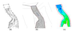
Topography forms the template of the modelling mesh which is draped over the boundary surface and which forms the basis for the numerical solution to the governing flow equations. The challenge of building a mesh is to distribute the nodes in such a way that the most accurate solution is obtained for a particular purpose. Closely spaced nodes in areas of high interest, gradual changes in node spacing, and regularity of elements are important considerations.
Outputs from the model are two (horizontal) velocity components and a depth at each point or node (Figure 2 and Figure 3). Velocity distributions in the vertical are assumed to be uniform and pressure distributions are assumed to be hydrostatic.
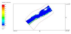
The fish habitat component of River2D is based on the Weighted Usable Area (WUA) (Bovee et al., 1998) concept used in the PHABSIM family of fish habitat models. The WUA is calculated as an aggregate of the product of a Composite Suitability Index (CSI, range 0.0 - 1.0) evaluated at every node in the domain and the "tributary area" associated with that node in the finite element mesh. The Suitability Index (SI) for each parameter is evaluated by linear interpolation from an appropriate Habitat Suitability Curves (HSC) to be supplied separately. Velocities and depths are taken directly from the hydrodynamic component of the model. The channel index values may depend on channel substrate or cover for different fish species and life stages. These values are interpolated from a separate channel index file to the computational nodes. The interpolation may be linear (continuous) or nearest neighbour (discrete). At the last stage, the River 2D computes the WUA (Figure 4) as the product, harmonic mean, or minimum value.
For habitat studies, the assumption is that the habitat is optimal when it reaches a maximum value of WUA (Figure 5).
The River 2D has been widely used to access the environmental flows (Rivaes et al., 2017), to study fish movements due to hydropeaking (Boavida et al., 2017; Yarnell et al., 2012), to calculate the suitability of spawning grounds (Gard, 2009), and for river restoration studies (Boavida et al., 2010; García de Jalón and Gortázar, 2007; Lacey and Millar, 2004).
Relevant mitigation measures and test cases
Other information
River 2D is a freeware available on the internet: http://www.river2d.ualberta.ca/
Relevant literature
- Boavida, I., Santos, J.M., Cortes, R., Pinheiro, A.N., Ferreira, M.T., 2010. Assessment of instream structures for habitat improvement for two critically endangered fish species. Aquat. Ecol. 45, 113–124.
- Boavida, I., Harby, A., Clarke, K.D., Heggenes, J., 2017. Move or stay: habitat use and movements by Atlantic salmon parr (Salmo salar) during induced rapid flow variations. Hydrobiologia 785, 261–275.
- Boavida I, Rivaes R, Santos JM. 2018. Transferability of environmental flows: a case-study in a Mediterranean river. In: Book of Abstracts - XIX Conference of the Iberian Association of Limnology. 24-29 June. Coimbra, Portugal.
- Boavida I, Caetano L, Pinheiro AN. 2020. E-flows to reduce the hydropeaking impacts on the Iberian barbel (Luciobarbus bocagei) habitat. An effectiveness assessment based on the COSH Tool application. Sci Total Environ 699:134209.
- Bovee, K.D., Lamb, B.L., Bartholow, J.M., Stalnaker, C.B., Taylor, J., Henriksen, J., Tatlor, J., Henriksen, J., 1998. Stream Habitat Analysis using the Instream Flow Incremental Methodology. U.S. Goelogical Surv. Biol. Resour. Div. Inf. Technol. Rep.
- García de Jalón, D., Gortázar, J., 2007. Evaluation of instream habitat enhancement options using fish habitat simulations: case-studies in the river Pas (Spain). Aquat. Ecol. 41, 461–474.
- Gard, M., 2009. Comparison of spawning habitat predictions of PHABSIM and River2D models. Int. J. River Basin Manag. 7, 55–71.
- Lacey, R.W.J., Millar, R.G., 2004. Reach scale hydraulic assessment of instream salmonid habitat restoration. J. Am. Water Resour. Assoc. 4, 1631–1644.
- Rivaes, R., Boavida, I., Santos, J.M., Pinheiro, A.N., Ferreira, T., 2017. Importance of considering riparian vegetation requirements for the long-term efficiency of environmental flows in aquatic microhabitats. Hydrol. Earth Syst. Sci. 21.
- Steffler, P., 2000. Software River2D. Two Dimensional Depth Averaged Finite Element Hydrodynamic Model. University of Alberta, Canada.
- Yarnell, S.M., Lind, A.J., Mount, J.F., 2012. Dynamic Flow Modelling of Riverine Amphibian Habitat with Application to Regulated Flow Management. River Res. Appl. 177–191.


