Placement of stones in the river
Contents
Introduction
In steeper rivers larger rocks are often naturally present, but these have sometimes been removed in order to improve the capacity to convey floods or to ease floating of timber. Larger stones provide shelter and resting places while smaller sized stones give interstitial space to shelter juvenile fish. Combined with changes in the reduction in large floods, sediment dynamics and clogging of the substrate, shelter can be the limiting factor ('bottleneck') in the development of the fish population. Placement of stones of the river will create hydraulic diversity and can be an efficient measure in reducing this bottleneck. Similar effect to adding new rocks to the river can be obtained by for instance ripping or cleaning of the substrate to remove finer sediment from the river bottom.
Classification table
|
Assessment criteria |
Assessment |
|
Fish species measure designed for |
Atlantic salmon (salmo salar) Trout (salmo trutta) |
|
Which life-stage of fish is measure aimed at? |
Shelter all life-stages |
|
Which physical parameter mitigated? |
Substrate, water velocity |
|
Section in the regulated system measure designed for |
Bypass section Upstream of hydropower plant Downstream outlet |
|
River type implemented in |
Gravel-bed rivers |
|
Climatic region suitable for |
C: Temperate (mesothermal) climates D: Continental (microthermal) climates E: Polar and alpine (montane) climates |
|
Level of certainty in effect |
Very certain |
|
Technology readiness level (maturity) |
TRL9: actual system proven in operational environment (competitive manufacturing in the case of key enabling technologies; or in space) |
Methods, tools, and devices
During planning
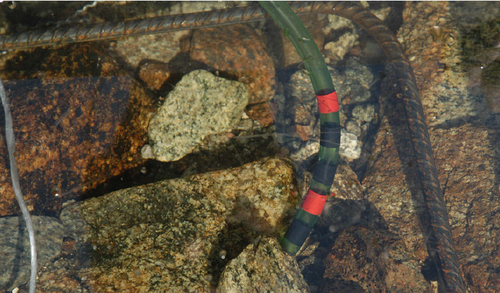
A first step in considering placement of stones in the river as a measure to increase the shelter would be to assess if this is the limiting factor for the development of fish population, i.e. diagnosis in the environmental design terminology. Larger stones (boulders) will provide shelter to larger fish, while smaller stones (pebbles, cobbles) will form interstitial spaces for smaller fish. The presence of larger stones can be found by visual inspection walking along the river, of by use of orthophoto, which further can be mapped in a GIS. Shelter for juvenile salmonids can be measured with a simple method where the number and depth of interstitial species within a given area is counted with use of a rubber tube (Finstad….).. The number of spaces of varying length are then summed, where the deeper holes assigned a larger weight than the less depth. The number of interstitial spaces within an area of 50 cm * 50 cm, limited by e.g. a steel-frame (Figure TT), is counted and the depth registered. The sizes of interstitial spaces are deter¬mined based on how far down between the rocks the hose can be inserted. Three shelter categories are recognised; S1: 2-5 cm, S2: 5-10 cm, and S3: >10 cm.
The average number of sheltered habitats for each of the three categories is calculated of each transect. These values are then summed up and weighed to give a value for "weighted shelter" after the following formula;
Sweighted = S1 + S2 * 2 + S3 * 3
|
Access to shelter (depth-weighted value) |
||
|
Poor |
Moderate |
Good |
|
<5 |
5-10 |
>10 |
There are no specific tools developed to assess the need for placement of stones for shelter in the rivers, according to the author's knowledge. There has, however, been promising attempts to relate output from hydraulic sediment models to the development of substrate characteristics, but this is still in the early stage. If models are capable to simulate the development over time, future maintenance needs can be estimated.
The effect of placing larger rocks in the river on shelter can be modelled with 3D hydraulic tools such as OpenFoam, Star-CCM+ and more. For a practical application it appears, however, that carrying out such a modelling exercise is a far too extensive job compared to the reduced uncertainty in the effect this might give. As such, use of 3D models must be considered mostly for research purpose.
During implementation
The implementation of this measure would require access to rocks of the right size and distribution. If such rocks are available from areas near areas, the need for transportation will be minimised, but the use of dumper and tractor must be counted in. Helicopter can also be an option in more remotely located areas. The placement of rocks in the river would normally require supervision of a biologist, hydraulic engineer or another experienced person in order to secure the right positioning.
During operation
Habitat measures in regulated rivers must often be maintained unless the natural functions related to flow and sediments are restored, such as flood events and connectivity of the sediments. How often the maintenance must be made will differ from river to river and can vary from for instance every 5 year to every 20 years. Rivers with larger volumes of fines, intense growth of moss, algae and macrophytes would need more frequent maintenance than rivers with cold water and low nutrient concentrations (less growth).


