Difference between revisions of "Anundsjö test case"
Bendikhansen (talk | contribs) |
Bendikhansen (talk | contribs) |
||
| Line 42: | Line 42: | ||
The work focused on the reservoir (CNRS, SWECO, NTNU), the bypassed river reach with the fishway (NTNU) and the junction of the hydropower plant tunnel outlet and the river (TUM, SWECO, NTNU). A telemetry study with smolt covered even a larger area including a stretch of the river upstream the reservoir and the downstream area until the bay of Örnsköldsvik (INBO). Scenario modelling applying different mitigation measures in a Bayesian network will all these areas (SINTEF). | The work focused on the reservoir (CNRS, SWECO, NTNU), the bypassed river reach with the fishway (NTNU) and the junction of the hydropower plant tunnel outlet and the river (TUM, SWECO, NTNU). A telemetry study with smolt covered even a larger area including a stretch of the river upstream the reservoir and the downstream area until the bay of Örnsköldsvik (INBO). Scenario modelling applying different mitigation measures in a Bayesian network will all these areas (SINTEF). | ||
| − | [[Acoustic Doppler current profiler (ADCP)|ADCP]] was used to map the bathymetry of the reservoir, serving as input for hydrodynamic modelling. Combined with telemetry study of smolts, it is clear that the current configuration of a floating debris collector and a guidance device actually prevents smolts from finding a safe downstream migration pathway. The telemetry study shows that only 1 smolt managed to find a safe way for downstream migration when released in the bypass section just below the dam. The one-hour release of water to the bypassed reach of river twice a week, do not reach the confluence of the hydropower plant outlet and the river within an hour, and the attraction effect is not very clear. Water velocities seem to be too low to allow migration into bypassed reach without additional release of water. Detailed measurements of water velocities by [[Acoustic Doppler | + | [[Acoustic Doppler current profiler (ADCP)|ADCP]] was used to map the bathymetry of the reservoir, serving as input for hydrodynamic modelling. Combined with telemetry study of smolts, it is clear that the current configuration of a floating debris collector and a guidance device actually prevents smolts from finding a safe downstream migration pathway. The telemetry study shows that only 1 smolt managed to find a safe way for downstream migration when released in the bypass section just below the dam. The one-hour release of water to the bypassed reach of river twice a week, do not reach the confluence of the hydropower plant outlet and the river within an hour, and the attraction effect is not very clear. Water velocities seem to be too low to allow migration into bypassed reach without additional release of water. Detailed measurements of water velocities by [[Acoustic Doppler velocimetry (ADV)|ADV]], and the use of drones and the [[Structure from motion (SfM)|Structure-from-motion-method]] to create bathymetry was used to validate the new [[Double Averaging method|double-averaging method]] of hydrodynamic modelling in 3D. |
=Gallery= | =Gallery= | ||
Revision as of 14:13, 8 October 2020
| Fact box: Anundsjö | |
|---|---|
| Country | Sweden |
| River | Mo (Moälven) |
| Operator | Statkraft |
| Capacity | 5 MW |
| Head | 61 m |
| Inter-annual discharge | 10 m3/s |
| Turbine(s) | 1 Francis turbine |
| Detailed report | Click for pdf |
Contents
Introduction
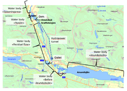
The Test Case is located on the small river Mo (Moälven) in the northern part of Sweden. The hydrology of the river Mo is typical for north of Sweden, with a lot of snow in the winter, a spring flood when the snow melts, low flows during the summer and often some higher flows and an autumn flood before the next winter starts with snow accumulation.
The catchment area is 820 km2. Mean annual precipitation for the whole catchment area is approx. 727 mm per year, with a mean flow at the outlet into the Baltic Sea of 27.9 m3/s, and 10.2 m3/s at the HPP Anundsjø.
About the hydropower plant
The HPP is impounding a small reservoir, releasing the water through the turbines and a tunnel back into the river about 4km further downstream. It has an installed capacity of 5 MW. The mean annual discharge is 10 m3/s with a low flow of 2.21 m3/s.
Layout
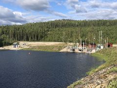
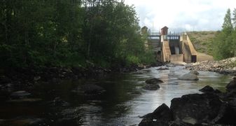
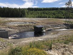
A small reservoir of 0.5 ha is located upstream of the HPP Anundsjø. A larger reservoir is located in a tributary about 10km further upstream, providing water releases during winter. There are important areas of spawning for salmon and trout further upstream. The bypassed river reach between the dam and the outlet of the power plant is 4 km. This bypassed river reach receives an environmental flow release.
The Operator: Statkraft
Statkraft is a leading company in hydropower internationally and Europe’s largest generator of renewable energy. The Group produces hydropower, wind power, solar power, gas-fired power and supplies district heating. Statkraft is a global company in energy market operations. It is Norway's largest and the Nordic region's second largest power producer. Read more.
Pressures on the water body's ecosystem
Due to two dams downstream of the HPP, for which the fish passage efficiency is unknown, the continuity is moderate. Most parts of the rapids further downstream have been modified for timber floating, with only a few being restored. Furthermore, the hydrology directly downstream of the power plant outlet is affected by short-time regulation. The water level in the small reservoir may fluctuate by up to 0.5 m. A recurring problem in Sweden is pollution through Mercury, which is released from the ground through logging activities, causing a moderate pollution of the water body.
Test case topics
Fish population
The fish species that can be found in the Mo are: salmon, sea trout, grayling, pike, perch, brown trout and crayfish. During the summer from July to October, the power plant is shut down twice a week for one hour, releasing the discharge through the gates in order attract salmon into the residual area. However, after one hour this flow has still not reached downstream to the outlet of the power plant.
Downstream migration
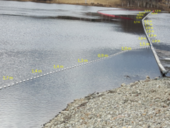
To facilitate better downstream fish migration, a floating guidance device is attached right next to the intake, leading the fish into a smolt trap and then out to the downstream side of the dam. The license of 2012 states that this device shall be placed out 1 May every year and water released in the smolt trap shall be 0.25 m3/s. This solution was evaluated together with the authorities after the first year, 2016, and the conclusion was that it did not work as intended. In 2017 a new solution with fishing nets was tested, leading the smolts to the fishway instead. The water released to the smolt trap was then instead released to go through the fishway. The starting time for the installation fot he guidance device is moved to a flexible time due to when the reservoir is ice-free.
Upstream migration
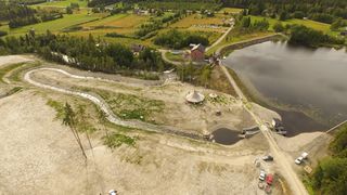
The upstream migrating fish encounter the outlet of the power plant, located 4 km downstream the fishway. The attraction flow is represented by the minimum flow, 0.8 m3/s between the 15th of July and the 5th of October; 0.25 m3/s the rest of the year. At the end of the 4 km long residual area the upstream migration continues in the nature-like fishway. At the end of the nature-like fishway, there is a short concrete fish ladder for the final ascent into the reservoir.
E-flow
In the new license from 2012, the requirements are release of water in the fishway between the 15th of July and the 5th of October of 0.8 m3/s and the rest of the year 0.25 m3/s. During the same period one hour every Tuesday and Thursday, the power plant must shut down and release the full discharge through the gates in order to attract salmon up in the residual area.
Research objectives and tasks
The overall question at the HPP Anundsjø is how FIThydro can improve the situation for fish by different measures and means around the HPP. This includes the situation for the salmon smolt, which are mainly arriving at the HPP after being released in the upstream area. It also includes the situation of juvenile fish of different species as well as the possibility for salmon to pass on the way to spawn and back (influenced also by the HPP located downstream of Anundsjø and influencing especially the number of migrating fish).
Research tasks
The research tasks and field studies conducted at Anundsjö are:
- Hydrodynamic conditions in the reservoir and their impact on downstream smolt migration
- Physical conditions in the nature-like fishway and its functionality for upstream migration of salmon
- Access and attraction to the bypassed river reach for upstream migration
- Use of advanced methods for mapping of bathymetry, measurements of water velocity and modelling
Results
The work focused on the reservoir (CNRS, SWECO, NTNU), the bypassed river reach with the fishway (NTNU) and the junction of the hydropower plant tunnel outlet and the river (TUM, SWECO, NTNU). A telemetry study with smolt covered even a larger area including a stretch of the river upstream the reservoir and the downstream area until the bay of Örnsköldsvik (INBO). Scenario modelling applying different mitigation measures in a Bayesian network will all these areas (SINTEF).
ADCP was used to map the bathymetry of the reservoir, serving as input for hydrodynamic modelling. Combined with telemetry study of smolts, it is clear that the current configuration of a floating debris collector and a guidance device actually prevents smolts from finding a safe downstream migration pathway. The telemetry study shows that only 1 smolt managed to find a safe way for downstream migration when released in the bypass section just below the dam. The one-hour release of water to the bypassed reach of river twice a week, do not reach the confluence of the hydropower plant outlet and the river within an hour, and the attraction effect is not very clear. Water velocities seem to be too low to allow migration into bypassed reach without additional release of water. Detailed measurements of water velocities by ADV, and the use of drones and the Structure-from-motion-method to create bathymetry was used to validate the new double-averaging method of hydrodynamic modelling in 3D.
