Difference between revisions of "HEC-RAS"
Bendikhansen (talk | contribs) |
Anaquaresma (talk | contribs) |
||
| (17 intermediate revisions by 3 users not shown) | |||
| Line 1: | Line 1: | ||
=Quick summary= | =Quick summary= | ||
| − | [[file: | + | [[file:casimir_gui.jpg|thumb|250px|Figure 1: HEC-RAS graphical user interface (GUI) (source: https://www.hec.usace.army.mil/software/hec-ras/).]] |
| − | [[file: | + | [[file:hecras_cross_sections.png|thumb|250px|Figure 2: HEC-RAS output: cross sections (source: https://www.hec.usace.army.mil/software/hec-ras/).]] |
| − | [[file: | + | [[file:hecras_profiles.png|thumb|250px|Figure 3: HEC-RAS output: river profiles (source: https://www.hec.usace.army.mil/software/hec-ras/).]] |
| − | [[file: | + | [[file:hecras_rating_curve.png|thumb|250px|Figure 4: HEC-RAS output: rating curve (source: https://www.hec.usace.army.mil/software/hec-ras/).]] |
| + | [[file:hecras_stage.png|thumb|250px|Figure 5: HEC-RAS output: hydrograph and stage(source: https://www.hec.usace.army.mil/software/hec-ras/).]] | ||
| + | [[file:hecras_mapper.jpg|thumb|250px|Figure 6: HEC-RAS output: inundation mapping (source: https://www.hec.usace.army.mil/software/hec-ras/).]] | ||
| + | [[file:hecras_output.png|thumb|250px|Figure 7: HEC-RAS output: tabular output (source: https://www.hec.usace.army.mil/software/hec-ras/).]] | ||
| − | Developed by: CEIWR-HEC, | + | Developed by: Hydrologic Engineering Center (CEIWR-HEC), United States Corps of Engineers (USACE)Institute for Water Resources |
| − | Date: | + | Date: July 1995 |
Type: [[:Category:Tools|Tool]] | Type: [[:Category:Tools|Tool]] | ||
| − | |||
=Introduction= | =Introduction= | ||
| − | HEC-RAS (Hydrologic Engineering Center-River Analysis System) is a freely available and widely used software tool for open channel flow analysis. The first version of the software, originally developed as a one-dimensional (1D) open channel flow analysis tool, was released in July 1995. In 2016 the ability to perform two-dimensional (2D) modelling was added. The current version allows users to perform | + | HEC-RAS (Hydrologic Engineering Center-River Analysis System) is a freely available and widely used software tool for open-channel flow analysis. The first version of the software, originally developed as a one-dimensional (1D) open-channel flow analysis tool, was released in July 1995. In 2016 the ability to perform two-dimensional (2D) modelling was added. The current version allows users to perform 1D/2D unsteady flow modelling, sediment transport/mobile bed computations, and water temperature/water quality modelling for a full network of natural and constructed channels, or a single river reach, under the same graphical user interface (GUI) (Figure 1). |
| − | The basic computational procedure of HEC-RAS for steady flow is based on the solution of the 1D energy equation | + | The basic computational procedure of HEC-RAS for steady flow is based on the solution of the 1D energy equation. The friction energy losses are computed by Manning’s equation, and the contraction/expansion head losses by coefficients multiplied by the change in velocity head. The momentum equation may be used in situations where the water surface is rapidly varied (e.g. hydraulic jumps, bridges, river confluences). For the 1D unsteady flow computation, HEC-RAS solves the full 1D Saint-Venant equation using an implicit finite difference method. For the 2D modelling the software solves either the 2D Saint- Venant equations, often referred to as the shallow water equations (with optional momentum additions for turbulence and Coriolis effects) or the 2D diffusion wave equations. This is user-selectable, giving users more flexibility. The shallow water equations solver disregards vertical velocities and assumes hydrostatic pressure, whereas the diffusive wave approximation solver additionally omits unsteady, advection and turbulent viscous terms, which narrows the range of applicability but has many computational advantages. Thus, in general, selection of the 2D diffusion wave equations allows the software to run faster, and has greater stability properties, whereas the 2D Saint-Venant equations are applicable to a wider range of problems. |
The 2D unsteady flow equations solver uses an Implicit Finite Volume algorithm. The implicit solution algorithm allows for larger computational time steps than explicit methods. The Finite Volume method guarantees improved stability and robustness over traditional finite difference and finite element techniques with the wetting and drying of 2D cells being very robust. | The 2D unsteady flow equations solver uses an Implicit Finite Volume algorithm. The implicit solution algorithm allows for larger computational time steps than explicit methods. The Finite Volume method guarantees improved stability and robustness over traditional finite difference and finite element techniques with the wetting and drying of 2D cells being very robust. | ||
| Line 22: | Line 24: | ||
The 2D modelling has a flexible mesh generation allowing the user to generate a computation grid that is a mixture of structured and unstructured mesh types with the possibility of containing a mixture of cell shapes (the model is limited to elements with up to eight sides) and sizes. A user can customize a mesh to suit the terrain, containing predominantly large orthogonal grid cells (which simplifies the numerical discretization, making it more efficient), and where needed smaller cells, orientated appropriately along controlling terrain such as road crests, or along important river channels. | The 2D modelling has a flexible mesh generation allowing the user to generate a computation grid that is a mixture of structured and unstructured mesh types with the possibility of containing a mixture of cell shapes (the model is limited to elements with up to eight sides) and sizes. A user can customize a mesh to suit the terrain, containing predominantly large orthogonal grid cells (which simplifies the numerical discretization, making it more efficient), and where needed smaller cells, orientated appropriately along controlling terrain such as road crests, or along important river channels. | ||
| − | + | In HEC-RAS, each computational cell and cell face is based on the details of the underlying terrain, which is referred to as ''high resolution subgrid model''. This allows larger cell sizes without compromising the resolution of the results, since it still accurately represents the underlying terrain, with gains in the modelling time. | |
=Application= | =Application= | ||
| − | HEC-RAS has a wide range of applications; it can be applied to river/open channel flow analysis, river rehabilitation/restoration studies, floodplain determination studies, hydraulic structures design and analysis (e.g. bridges, weirs, culverts), sediment transport studies, scour/deposition analysis, dam break analysis (e.g. timing of flood, flood inundation), and water quality analysis. | + | HEC-RAS has a wide range of applications; it can be applied to river/open-channel flow analysis, river rehabilitation/restoration studies, floodplain determination studies, hydraulic structures design and analysis (e.g. bridges, weirs, culverts), sediment transport studies, scour/deposition analysis, dam break analysis (e.g. timing of flood, flood inundation), and water quality analysis. |
| − | As input data, it requires geometry data, like topography (e.g. surveyed cross sections, digital elevation model), energy losses (e.g. roughness, expansions and contractions), and hydraulic structures (e.g. bridges, culverts, weirs). Hydrology data (e.g. gauging stations data, measured/observed flow and water depth data) | + | As input data, it requires geometry data, like topography (e.g. surveyed cross sections, digital elevation model), energy losses (e.g. roughness, expansions and contractions), and hydraulic structures (e.g. bridges, culverts, weirs). Hydrology data (e.g. gauging stations data, measured/observed flow and water depth data) are also needed for calibration/validation and/or boundary conditions. If sediment transport or water quality studies are intended, sediment data (e.g. representative material, appropriate transport equations, appropriate sorting and fall velocity methods) and water quality data (e.g. meteorological data, nutrients data) are required, respectively. |
HEC-RAS has an internal GIS tool (RAS Mapper) which provides flexible viewing and manipulation of integrated 1D and 2D results, greatly enhancing the pre- and post-processing capabilities of data within the software. | HEC-RAS has an internal GIS tool (RAS Mapper) which provides flexible viewing and manipulation of integrated 1D and 2D results, greatly enhancing the pre- and post-processing capabilities of data within the software. | ||
| − | Outputs of HEC-RAS include graphics, like X-Y plots of the river system schematic, cross-sections (Figure | + | Outputs of HEC-RAS include graphics, like X-Y plots of the river system schematic, cross-sections (Figure 2), profiles (Figure 3), rating curves (Figure 4), hydrographs (Figure 5), and inundation mapping (Figure 6). Inundation maps can contain multiple background layers, like terrain and aerial photography, and additional geospatial data can be generated for the analysis of velocity, shear stress, stream power, ice thickness and floodway encroachment data. Tabular output (Figure 7) is available with the possibility of selecting pre-defined tables or developing customized tables. The graphical and tabular output can be exported to other software, such as a word-processor or a spreadsheet. |
| − | The current version (5.0. | + | The current version (5.0.7) cannot perform sediment transport and water quality modelling in 2D flow areas, nor use HEC-RAS bridge modelling capabilities inside of a 2D flow area, nor connect pump stations to 2D flow area cells. |
| + | |||
| + | =Relevant mitigation measures and test cases= | ||
| + | {{Suitable measures for HEC-RAS}} | ||
=Other information= | =Other information= | ||
| − | HEC-RAS is freely available | + | HEC-RAS is freely available at: https://www.hec.usace.army.mil/software/hec-ras/. |
| − | Since the software is continuously under development, users are encouraged to submit suggestions | + | Since the software is continuously under development, users are encouraged to submit suggestions and requests for enhancement, or to report bugs or possible errors, so current limitations and new additions are worked on to have solutions and improvements in future versions. |
| − | The 2D modelling is done with a multi-processor based solution algorithm (parallel computing) to take advantage of multiple processors on a computer, allowing it to run much faster than on a single processor. | + | The 2D modelling is done with a multi-processor based solution algorithm (parallel computing), to take advantage of multiple processors on a computer, allowing it to run much faster than on a single processor. |
| − | HEC-RAS is compatible with several GIS software. HEC-GEO-RAS is an extension for ArcGIS which allows for the pre-processing of geometric data to import to HEC-RAS and the post-processing of the results. It was developed by CEIWR-HEC together with ESRI (Environmental System Research Institute). RiverGIS is a QGIS | + | HEC-RAS is compatible with several GIS software. HEC-GEO-RAS is an extension for ArcGIS which allows for the pre-processing of geometric data to import to HEC-RAS and the post-processing of the results. It was developed by CEIWR-HEC together with ESRI (Environmental System Research Institute). RiverGIS is a QGIS plug-in for creating HEC-RAS flow model geometry from spatial data, and is a free software released under the GNU General Public License. |
=Relevant literature= | =Relevant literature= | ||
| Line 48: | Line 53: | ||
=Contact information= | =Contact information= | ||
| − | + | hec.ras@usace.army.mil | |
| − | |||
| − | |||
[[Category:Tools]] | [[Category:Tools]] | ||
Latest revision as of 13:38, 29 September 2020
Contents
Quick summary

Developed by: Hydrologic Engineering Center (CEIWR-HEC), United States Corps of Engineers (USACE)Institute for Water Resources
Date: July 1995
Type: Tool
Introduction
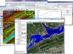
HEC-RAS (Hydrologic Engineering Center-River Analysis System) is a freely available and widely used software tool for open-channel flow analysis. The first version of the software, originally developed as a one-dimensional (1D) open-channel flow analysis tool, was released in July 1995. In 2016 the ability to perform two-dimensional (2D) modelling was added. The current version allows users to perform 1D/2D unsteady flow modelling, sediment transport/mobile bed computations, and water temperature/water quality modelling for a full network of natural and constructed channels, or a single river reach, under the same graphical user interface (GUI) (Figure 1).
The basic computational procedure of HEC-RAS for steady flow is based on the solution of the 1D energy equation. The friction energy losses are computed by Manning’s equation, and the contraction/expansion head losses by coefficients multiplied by the change in velocity head. The momentum equation may be used in situations where the water surface is rapidly varied (e.g. hydraulic jumps, bridges, river confluences). For the 1D unsteady flow computation, HEC-RAS solves the full 1D Saint-Venant equation using an implicit finite difference method. For the 2D modelling the software solves either the 2D Saint- Venant equations, often referred to as the shallow water equations (with optional momentum additions for turbulence and Coriolis effects) or the 2D diffusion wave equations. This is user-selectable, giving users more flexibility. The shallow water equations solver disregards vertical velocities and assumes hydrostatic pressure, whereas the diffusive wave approximation solver additionally omits unsteady, advection and turbulent viscous terms, which narrows the range of applicability but has many computational advantages. Thus, in general, selection of the 2D diffusion wave equations allows the software to run faster, and has greater stability properties, whereas the 2D Saint-Venant equations are applicable to a wider range of problems. The 2D unsteady flow equations solver uses an Implicit Finite Volume algorithm. The implicit solution algorithm allows for larger computational time steps than explicit methods. The Finite Volume method guarantees improved stability and robustness over traditional finite difference and finite element techniques with the wetting and drying of 2D cells being very robust.
The 1D and 2D solution algorithms are tightly coupled on a time step basis with an option to iterate between 1D and 2D flow transfers within a time step. This allows for direct feedback at each time step between the 1D and 2D flow elements.
The 2D modelling has a flexible mesh generation allowing the user to generate a computation grid that is a mixture of structured and unstructured mesh types with the possibility of containing a mixture of cell shapes (the model is limited to elements with up to eight sides) and sizes. A user can customize a mesh to suit the terrain, containing predominantly large orthogonal grid cells (which simplifies the numerical discretization, making it more efficient), and where needed smaller cells, orientated appropriately along controlling terrain such as road crests, or along important river channels.
In HEC-RAS, each computational cell and cell face is based on the details of the underlying terrain, which is referred to as high resolution subgrid model. This allows larger cell sizes without compromising the resolution of the results, since it still accurately represents the underlying terrain, with gains in the modelling time.
Application
HEC-RAS has a wide range of applications; it can be applied to river/open-channel flow analysis, river rehabilitation/restoration studies, floodplain determination studies, hydraulic structures design and analysis (e.g. bridges, weirs, culverts), sediment transport studies, scour/deposition analysis, dam break analysis (e.g. timing of flood, flood inundation), and water quality analysis.
As input data, it requires geometry data, like topography (e.g. surveyed cross sections, digital elevation model), energy losses (e.g. roughness, expansions and contractions), and hydraulic structures (e.g. bridges, culverts, weirs). Hydrology data (e.g. gauging stations data, measured/observed flow and water depth data) are also needed for calibration/validation and/or boundary conditions. If sediment transport or water quality studies are intended, sediment data (e.g. representative material, appropriate transport equations, appropriate sorting and fall velocity methods) and water quality data (e.g. meteorological data, nutrients data) are required, respectively.
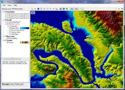
HEC-RAS has an internal GIS tool (RAS Mapper) which provides flexible viewing and manipulation of integrated 1D and 2D results, greatly enhancing the pre- and post-processing capabilities of data within the software.
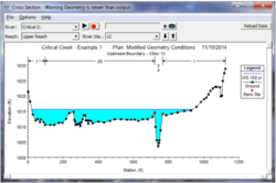
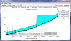
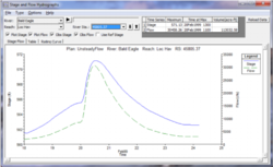
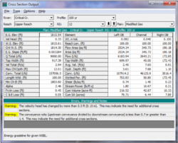
Outputs of HEC-RAS include graphics, like X-Y plots of the river system schematic, cross-sections (Figure 2), profiles (Figure 3), rating curves (Figure 4), hydrographs (Figure 5), and inundation mapping (Figure 6). Inundation maps can contain multiple background layers, like terrain and aerial photography, and additional geospatial data can be generated for the analysis of velocity, shear stress, stream power, ice thickness and floodway encroachment data. Tabular output (Figure 7) is available with the possibility of selecting pre-defined tables or developing customized tables. The graphical and tabular output can be exported to other software, such as a word-processor or a spreadsheet.
The current version (5.0.7) cannot perform sediment transport and water quality modelling in 2D flow areas, nor use HEC-RAS bridge modelling capabilities inside of a 2D flow area, nor connect pump stations to 2D flow area cells.
Relevant mitigation measures and test cases
Other information
HEC-RAS is freely available at: https://www.hec.usace.army.mil/software/hec-ras/. Since the software is continuously under development, users are encouraged to submit suggestions and requests for enhancement, or to report bugs or possible errors, so current limitations and new additions are worked on to have solutions and improvements in future versions.
The 2D modelling is done with a multi-processor based solution algorithm (parallel computing), to take advantage of multiple processors on a computer, allowing it to run much faster than on a single processor.
HEC-RAS is compatible with several GIS software. HEC-GEO-RAS is an extension for ArcGIS which allows for the pre-processing of geometric data to import to HEC-RAS and the post-processing of the results. It was developed by CEIWR-HEC together with ESRI (Environmental System Research Institute). RiverGIS is a QGIS plug-in for creating HEC-RAS flow model geometry from spatial data, and is a free software released under the GNU General Public License.
Relevant literature
- https://www.hec.usace.army.mil/software/hec-ras/
- https://www.hec.usace.army.mil/software/hec-ras/documentation.aspx
Contact information
hec.ras@usace.army.mil