Difference between revisions of "Bannwil test case"
Robert Boes (talk | contribs) |
Bendikhansen (talk | contribs) |
||
| (13 intermediate revisions by 3 users not shown) | |||
| Line 8: | Line 8: | ||
The river Aare is a 291 km long tributary of the Rhine and the longest river within Switzerland. The Aare River passes through three major lakes: Lake of Brienz, Lake of Thun and Lake of Biel. | The river Aare is a 291 km long tributary of the Rhine and the longest river within Switzerland. The Aare River passes through three major lakes: Lake of Brienz, Lake of Thun and Lake of Biel. | ||
| − | + | There are in total 12 HPPs on the Aare river stretch between Lake Biel and the junction with the Rhine river, and two nuclear power plants with water abstraction for cooling. | |
| − | The altitude of the lowest and highest points of this river reach are ca. 312 m a.s.l. and 429 m a.s.l., respectively. The average altitude of the whole catchment amounts to 1060 m a.s.l. and the whole catchment area is 17687 km<sup>2</sup>, of which 1.4 % are covered by glaciers. On the river Aare, the mean monthly discharge increases from February to June and then decreases from July to October. The annual discharge | + | The altitude of the lowest and highest points of this river reach are ca. 312 m a.s.l. and 429 m a.s.l., respectively. The average altitude of the whole catchment amounts to 1060 m a.s.l. and the whole catchment area is 17687 km<sup>2</sup>, of which 1.4 % are covered by glaciers. On the river Aare, the mean monthly discharge increases from February to June and then decreases from July to October. The multi-year annual discharge amounts to 268 m<sup>3</sup>/s. |
=About the hydropower plant= | =About the hydropower plant= | ||
| − | |||
| − | |||
| + | The Bannwil weir is located on the right side of the river, while the powerhouse is located on the left side. The reservoir impoundment is about 7 km long. With three bulb turbines, HPP Bannwil has an installed capacity of 28.5 MW and an average annaul production of 150 GWh. The gross head amounts to 5.5 - 8.5 m, depending on the up- and downstream water levels, with a designed discharge of 450 m<sup>3</sup>/s. | ||
===The Operator: BKW=== | ===The Operator: BKW=== | ||
HPP Bannwil is operated by the BKW group. The group plans, builds and operates infrastructure to produce and supply energy to businesses, households and the public sector, and offers digital business models for renewable energies. [https://www.bkw.ch/en/about-us/company/about-us/ Read more.] | HPP Bannwil is operated by the BKW group. The group plans, builds and operates infrastructure to produce and supply energy to businesses, households and the public sector, and offers digital business models for renewable energies. [https://www.bkw.ch/en/about-us/company/about-us/ Read more.] | ||
=Pressures on the water body's ecosystem= | =Pressures on the water body's ecosystem= | ||
| − | The river Aare is located in the Rhine river catchment, which was historically one of the most important Atlantic salmon (Salmo salar) rivers in Europe. The upstream migration of salmons in the Rhine catchment became almost impossible after intense hydropower plant constructions, including the Aare river catchment. All of the occurring fish species present in the Aare river (total of 44 fish species) face potentially high mortality during downstream migration or difficulties during upstream migration. | + | The river Aare is located in the Rhine river catchment, which was historically one of the most important Atlantic salmon (''Salmo salar'') rivers in Europe. The upstream migration of salmons in the Rhine catchment became almost impossible after intense hydropower plant constructions, including the Aare river catchment. All of the occurring fish species present in the Aare river (total of 44 fish species) face potentially high mortality during downstream migration or difficulties during upstream migration. |
Furthermore, the river Aare is highly influenced by hydropower and considered as a heavily modified water body. Moreover, there are three nuclear power plants on the Aare river, two of them reintroducing the used cooling water, which induces an increase of the river water temperature. The river has a moderate ecological potential. Measures for sediment control, fish migration, flow changes, habitat in-channel and morphology off-channel have been implemented in the water body. | Furthermore, the river Aare is highly influenced by hydropower and considered as a heavily modified water body. Moreover, there are three nuclear power plants on the Aare river, two of them reintroducing the used cooling water, which induces an increase of the river water temperature. The river has a moderate ecological potential. Measures for sediment control, fish migration, flow changes, habitat in-channel and morphology off-channel have been implemented in the water body. | ||
| Line 32: | Line 31: | ||
The fish pass needs to be restructured to accommodate larger fish in the near future. Current plans include replacing the lower part with a vertical slot pass and the upper part with a nature like open channel pass. | The fish pass needs to be restructured to accommodate larger fish in the near future. Current plans include replacing the lower part with a vertical slot pass and the upper part with a nature like open channel pass. | ||
| + | |||
| + | ===Downstream migration=== | ||
| + | There is no specific measures implemented at HPP Bannwil. Fish can pass through the turbines and/or over the weirs when they are in operation. Weir discharge occurs on average (1935-2015) for about 42 days per year. | ||
=Research objectives and tasks= | =Research objectives and tasks= | ||
| Line 44: | Line 46: | ||
=Results= | =Results= | ||
| + | |||
| + | The results of the studies on downstream fish migration at HPP Bannwil indicate that no fish injury is expected during fish spillway passage since fish terminal velocity is higher than the weir velocity. However, due to back-roll in the stilling basin of spillway, fish might be exposed to increased predation or strike to baffle blocks. Numerical model results also indicate that hydraulic conditions at potential positions of a fish guidance structure in front of the turbines are unfavorable. | ||
| + | |||
| + | Analysis of the Biological Performance Assessment (BioPA) based on the CFD simulation of the turbines indicate that the average fish friendliness scores of the HPP Bannwil are 9.1 and 8.5 out of 10 at an acclimation depth of 5 m and 10 m, respectively. The former i.e. 5 m is more realistic for the HPP regarding the depth of the river. For an absolute fish survival rating, this factor plays an important role. | ||
=Gallery= | =Gallery= | ||
<gallery mode=packed> | <gallery mode=packed> | ||
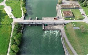
HPP Bannwil River Aare.jpg|Aerial view of Bannwil HPP; flow direction from top to bottom. | HPP Bannwil River Aare.jpg|Aerial view of Bannwil HPP; flow direction from top to bottom. | ||
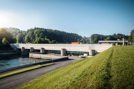
| − | HPP Bannwil River Aare2.jpg| | + | HPP Bannwil River Aare2.jpg|View of Bannwil HPP from downstream [1]. |
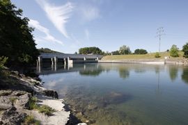
| − | HPP Bannwil River Aare3.jpg| | + | HPP Bannwil River Aare3.jpg|View of Bannwil HPP from downstream [2]. |
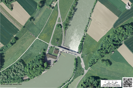
| − | Bannwil Layout.png|Layout of the Bannwil HPP and surrounding area | + | Bannwil Layout.png|Layout of the Bannwil HPP and surrounding area; flow direction from bottom to top. |
</gallery> | </gallery> | ||
Latest revision as of 14:03, 8 June 2021
| Fact box: Bannwil | |
|---|---|
| Country | Switzerland |
| River | Aare |
| Operator | BKW Energie AG |
| Capacity | 28.5 MW |
| Head | 5.5 - 8.5 m |
| Inter-annual discharge | 268 m3/s |
| Turbine(s) | 3 Bulb turbines |
| Detailed report | Click for pdf |
Contents
Introduction
The Bannwil hydropower plant (HPP) is a run-of-the-river HPP on the river Aare located in the community of Bannwil, some 46 km downstream of Lake Biel. There are two upstream HPPs on the Aare river below Lake Biel, HPP Brügg at the lake outflow and HPP Flumenthal about 12 km from Bannwil.
The river Aare is a 291 km long tributary of the Rhine and the longest river within Switzerland. The Aare River passes through three major lakes: Lake of Brienz, Lake of Thun and Lake of Biel.
There are in total 12 HPPs on the Aare river stretch between Lake Biel and the junction with the Rhine river, and two nuclear power plants with water abstraction for cooling.
The altitude of the lowest and highest points of this river reach are ca. 312 m a.s.l. and 429 m a.s.l., respectively. The average altitude of the whole catchment amounts to 1060 m a.s.l. and the whole catchment area is 17687 km2, of which 1.4 % are covered by glaciers. On the river Aare, the mean monthly discharge increases from February to June and then decreases from July to October. The multi-year annual discharge amounts to 268 m3/s.
About the hydropower plant
The Bannwil weir is located on the right side of the river, while the powerhouse is located on the left side. The reservoir impoundment is about 7 km long. With three bulb turbines, HPP Bannwil has an installed capacity of 28.5 MW and an average annaul production of 150 GWh. The gross head amounts to 5.5 - 8.5 m, depending on the up- and downstream water levels, with a designed discharge of 450 m3/s.
The Operator: BKW
HPP Bannwil is operated by the BKW group. The group plans, builds and operates infrastructure to produce and supply energy to businesses, households and the public sector, and offers digital business models for renewable energies. Read more.
Pressures on the water body's ecosystem
The river Aare is located in the Rhine river catchment, which was historically one of the most important Atlantic salmon (Salmo salar) rivers in Europe. The upstream migration of salmons in the Rhine catchment became almost impossible after intense hydropower plant constructions, including the Aare river catchment. All of the occurring fish species present in the Aare river (total of 44 fish species) face potentially high mortality during downstream migration or difficulties during upstream migration.
Furthermore, the river Aare is highly influenced by hydropower and considered as a heavily modified water body. Moreover, there are three nuclear power plants on the Aare river, two of them reintroducing the used cooling water, which induces an increase of the river water temperature. The river has a moderate ecological potential. Measures for sediment control, fish migration, flow changes, habitat in-channel and morphology off-channel have been implemented in the water body.
Test case topics
Fish population
There are a total of 44 fish species in the river Aare, amongst which eel (Anguilla anguilla), brown trout (Salmo trutta), chub (Squalius cephalus), grayling (Tymallus thymallus), spirlin (Alburnus alburnus), and common barbel (Barbus barbus). Salmon is expected to come back in the next 10-20 years after construction and upgrading of fish passes at HPPs on the Rhine river.
Upstream migration
The current fish pass is a pool-type design with bottom and top openings. The entrance is located on the left shore shortly downstream of the powerhouse. The bottom slope of the technical fish pass is on average 6 %. Most of the head difference is accomplished in the first half of the fishway consisting of pools placed spirally. The upper part of the fishway consists of a nearly horizontal channel that leads to the exit roughly 100 m upstream of the HPP axis. The mean discharge in the fishway amounts to 350 l/s.
The fish pass needs to be restructured to accommodate larger fish in the near future. Current plans include replacing the lower part with a vertical slot pass and the upper part with a nature like open channel pass.
Downstream migration
There is no specific measures implemented at HPP Bannwil. Fish can pass through the turbines and/or over the weirs when they are in operation. Weir discharge occurs on average (1935-2015) for about 42 days per year.
Research objectives and tasks
At Bannwil HPP, downstream fish migration measures are investigated by means of field and CFD studies. The current situation and the efficiency of spill flow or water release as an operational measure at HPP Bannwil are investigated through field monitoring and 3-D numerical modelling in the areas near the powerhouse and weir. Applying this model to different structural and/or operational scenarios gives hints to solutions to improve fish migration at reduced energy losses. Dynamic pressure fluctuations experienced by fish during the turbine and spillway passages are studied at HPP Bannwil using a Barotrauma Detection System (BDS) developed at TUT. Based on the data, a CFD-model will be developed, which can then be used to evaluate the fish passage in order to judge the possibility of adapting the hydropower operation for certain time periods.
Research tasks
The research tasks and field studies conducted at HPP Bannwil are:
- Velocity & hydraulic measurements
- 3D turbine & HPP CFD models with Biological Performance Assessment and Barotrauma Detection System
- Fish monitoring; Survey of fish movement using ARIS Sonar and radio telemetry techniques
- Variant Study
Results
The results of the studies on downstream fish migration at HPP Bannwil indicate that no fish injury is expected during fish spillway passage since fish terminal velocity is higher than the weir velocity. However, due to back-roll in the stilling basin of spillway, fish might be exposed to increased predation or strike to baffle blocks. Numerical model results also indicate that hydraulic conditions at potential positions of a fish guidance structure in front of the turbines are unfavorable.
Analysis of the Biological Performance Assessment (BioPA) based on the CFD simulation of the turbines indicate that the average fish friendliness scores of the HPP Bannwil are 9.1 and 8.5 out of 10 at an acclimation depth of 5 m and 10 m, respectively. The former i.e. 5 m is more realistic for the HPP regarding the depth of the river. For an absolute fish survival rating, this factor plays an important role.


