Difference between revisions of "Günz test case"
| (8 intermediate revisions by 3 users not shown) | |||
| Line 4: | Line 4: | ||
=Introduction= | =Introduction= | ||
| − | The river Günz is located in the southern part of Bavaria, Germany. It is about | + | The river Günz is located in the southern part of Bavaria, Germany. It is about 60 km long and flows into the river Danube near the city Günzburg. The catchment area of the river Günz is 710 km<sup>2</sup>. The Günz is fed by the confluence of the “Eastern Günz” and the “Western Günz” near the small city Lauben. The Test Case consists of a row of 5 hydropower plants, which are located on the Günz. |
The hydrology of the Günz is characterized by flood peaks in winter due to snow melting and some flood peaks in the summer after heavy rain events. The catchment area of the river Günz is 710 km<sup>2</sup> The mean interannual discharge of the river Günz is estimated at 7.8 m<sup>3</sup>/s. The river is classified with a moderate ecological status. | The hydrology of the Günz is characterized by flood peaks in winter due to snow melting and some flood peaks in the summer after heavy rain events. The catchment area of the river Günz is 710 km<sup>2</sup> The mean interannual discharge of the river Günz is estimated at 7.8 m<sup>3</sup>/s. The river is classified with a moderate ecological status. | ||
| Line 10: | Line 10: | ||
=About the hydropower plants= | =About the hydropower plants= | ||
The Test Case Günz comprises 5 consecutive hydropower plants. Four of them are run-of-river hydropower plants and one, the HPP Oberegg, has a diverted reach. | The Test Case Günz comprises 5 consecutive hydropower plants. Four of them are run-of-river hydropower plants and one, the HPP Oberegg, has a diverted reach. | ||
| − | Each of the 5 HPPs is equipped with one Kaplan-turbine, with installed capacities of 350 kW at Waldstetten, | + | Each of the 5 HPPs is equipped with one Kaplan-turbine, with installed capacities of 350 kW at Waldstetten, 550 kW at Höselhurst, 520 kW at Wattenweiler, 720 kW at Ellzee and 1100 kW at Oberegg. The annual output is between 1.4 - 3.1 GWh . The height drop ranges from 3.9 to 8.3 m at the different HPPs. |
===Layout=== | ===Layout=== | ||
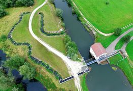
The HPPs Höselhurst, Wattenweiler, Ellzee and Waldstetten are run-of-river HPPs, the HPP Oberegg is a diversion hydropower plant (Ausleitungskraftwerk). In the upstream areas of the HPPs there are reservoirs. In the downstream areas the river Günz is still free flowing until the head of the next reservoir. There is a fish bypass channel at every HPP. At the run-of river HPPs they are built as a classical conventional pond system. At Oberegg the fish passage facility for upstream fish migration is integrated into the diverted reach, which is called “Alte Günz”. | The HPPs Höselhurst, Wattenweiler, Ellzee and Waldstetten are run-of-river HPPs, the HPP Oberegg is a diversion hydropower plant (Ausleitungskraftwerk). In the upstream areas of the HPPs there are reservoirs. In the downstream areas the river Günz is still free flowing until the head of the next reservoir. There is a fish bypass channel at every HPP. At the run-of river HPPs they are built as a classical conventional pond system. At Oberegg the fish passage facility for upstream fish migration is integrated into the diverted reach, which is called “Alte Günz”. | ||
| − | ===The Operator: | + | ===The Operator: LEW Wasserkraft GmbH (LEW)=== |
| − | The | + | The LEW Wasserkraft is a 100 % subsidiary of the Lechwerke AG. It runs and maintains 36 HPPs at the rivers Danube, Günz, Lech and Iller and is thereby one of the leading HPP operators in Bavaria, Germany. The company produces over 1 billion kWh energy out of regenerative hydropower per year. [https://wasserkraft.lew.de/lew-wasserkraft] |
=Pressures on the water body's ecosystem= | =Pressures on the water body's ecosystem= | ||
| − | The main pressures on the water body are hydrology, agricultural use of pesticides, effluents from a nearby water treatment plant, and to some extent the spill over from storm water overflow. Previously, continuity was classified as a high pressure, but this was counteracted through the building of fishways in 2014. The pressures are mainly caused of morphological issues which are results of the HPP. There is a lack of important habitats like juvenile habitats, spawning habitats and the reophilic interstitial. The | + | The main pressures on the water body are hydrology, agricultural use of pesticides, effluents from a nearby water treatment plant, and to some extent the spill over from storm water overflow. Previously, continuity was classified as a high pressure, but this was counteracted through the building of fishways in 2014. The pressures are mainly caused of morphological issues which are results of the HPP. There is a lack of important habitats like juvenile habitats, spawning habitats and the reophilic interstitial. The LEW is working on this problems with a restauration program. |
=Test case topics= | =Test case topics= | ||
| Line 35: | Line 35: | ||
* Potential test of CIA tools | * Potential test of CIA tools | ||
* Management, monitoring and construction of spawning habitats in fishway | * Management, monitoring and construction of spawning habitats in fishway | ||
| − | * Numerical | + | * Numerical simulations of flow and habitat conditions in the fishway |
| + | |||
=Results= | =Results= | ||
| + | In February 2018 and 2019, gravel was implemented as a spawning ground in 4 of the 5 fish passes of LEW Wasserkraft at the river Günz. Afterwards the spawning activities were monitored on a daily basis. A special focus was put on the nase (Chondrostoma nasus), which was very common in former times in the Günz, like in the “barb region” of most rivers in Bavaria. | ||
| + | |||
| + | The nase was selected as a success indicator for the design of the spawning grounds, because their spawning activities depend on the water temperature. | ||
| + | |||
| + | In 2018 the successful spawning of the nase could be verified at the fish pass in Wattenweiler all over the area, where new gravel was implemented. Many eggs were found in that section, just a view days after the gravel was inserted. In the other fish passes downstream, no eggs were found in that year. This was probably because the spawning season of the nase was very early in spring 2018 and the adding of gravel happened too late for that. In 2019 spawning nase were found in all fish passes with ponds with new gravel, but also in ponds where the gravel from the first year was mechanically re-allocated. While the coarse substrates of the initial situation were also used for spawning (nase and dace (Leuciscus leuciscus), the numbers showed that the nase clearly prefers the ponds with new gravel. | ||
| + | |||
| + | The gravel ponds, prepared in 2018, had a relatively strong grade of colmation in 2019, which means that the gaps between the gravel was filled with fine sediments. However, the gravel still was still loose enough for the fish to re-allocate it when preparing their spawning pits. The colmation of the substrate is caused by the static water flow from the main river, which is common in all fish passes. A natural dynamic, in terms of a re-allocation of the bed load, is missing. As the fish were found to prefer new, clean gravel, this results in an expected very good functioning of the new spawning grounds for about two year. | ||
| + | |||
| + | A recommendation from these findings is therefore to include the option to “irrigate” the ponds, when planning the construction of a new fish pass. This could be achieved, for example, with additional pipes that cross the dam. They offer the opportunity to multiplicate the water flow temporarily, enabling a certain nature-like dynamic with a re-allocation of the substrates. | ||
| + | |||
| + | To conclude, the preparation of spawning grounds in existing fish passes by inserting gravel, was a great success, also in terms of a good cost-benefit-ratio. | ||
=Gallery= | =Gallery= | ||
| Line 42: | Line 54: | ||
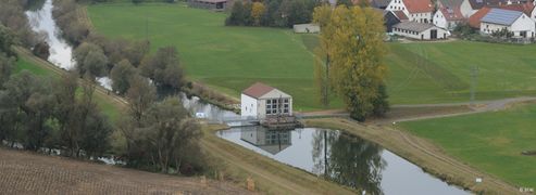
Gunz_elizee_HPP.jpg| The hydropower plant Ellzee on the river Günz (source: LEW). | Gunz_elizee_HPP.jpg| The hydropower plant Ellzee on the river Günz (source: LEW). | ||
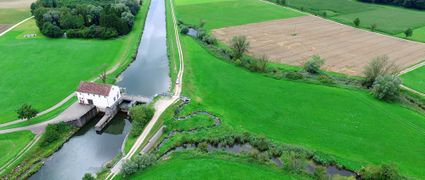
Gunz_hosenhurst_hpp.jpg|The hydropower plant Hösellhurst with fish pass on the river Günz (source: Olav König). | Gunz_hosenhurst_hpp.jpg|The hydropower plant Hösellhurst with fish pass on the river Günz (source: Olav König). | ||
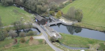
| − | Gunz_oberegg_hpp.jpg|The hydropower plant Oberegg | + | Gunz_oberegg_hpp.jpg|The diversion weir at Deisenhausen, upstream of the hydropower plant Oberegg (source: LEW). |
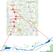
Günz-layout.png|Location of the 5 test case hydropower plants on the Günz river (source: LEW). | Günz-layout.png|Location of the 5 test case hydropower plants on the Günz river (source: LEW). | ||
HPP-Ellzee-nature-like-fishway.jpg|View of the hydropower plant and nature like fishway at Ellzee (source: Olav König). | HPP-Ellzee-nature-like-fishway.jpg|View of the hydropower plant and nature like fishway at Ellzee (source: Olav König). | ||
gunz-nature-like-fishway.jpg|Close-up of a nature-like fishway in the Günz river (source: Nicole Kalinowski, IBF Umwelt). | gunz-nature-like-fishway.jpg|Close-up of a nature-like fishway in the Günz river (source: Nicole Kalinowski, IBF Umwelt). | ||
</gallery> | </gallery> | ||
| − | |||
| − | |||
Latest revision as of 14:55, 23 October 2020
| Fact box: Günz | |
|---|---|
| Country | Germany |
| River | Günz |
| Operator | LEW |
| Capacity | 350 - 1100 kW |
| Head | 5 m |
| Inter-annual discharge | 7.8 m3/s |
| Turbine(s) | 1 Kaplan turbine at every HPP |
| Detailed report | Click for pdf |
Contents
Introduction
The river Günz is located in the southern part of Bavaria, Germany. It is about 60 km long and flows into the river Danube near the city Günzburg. The catchment area of the river Günz is 710 km2. The Günz is fed by the confluence of the “Eastern Günz” and the “Western Günz” near the small city Lauben. The Test Case consists of a row of 5 hydropower plants, which are located on the Günz.
The hydrology of the Günz is characterized by flood peaks in winter due to snow melting and some flood peaks in the summer after heavy rain events. The catchment area of the river Günz is 710 km2 The mean interannual discharge of the river Günz is estimated at 7.8 m3/s. The river is classified with a moderate ecological status.
About the hydropower plants
The Test Case Günz comprises 5 consecutive hydropower plants. Four of them are run-of-river hydropower plants and one, the HPP Oberegg, has a diverted reach. Each of the 5 HPPs is equipped with one Kaplan-turbine, with installed capacities of 350 kW at Waldstetten, 550 kW at Höselhurst, 520 kW at Wattenweiler, 720 kW at Ellzee and 1100 kW at Oberegg. The annual output is between 1.4 - 3.1 GWh . The height drop ranges from 3.9 to 8.3 m at the different HPPs.
Layout
The HPPs Höselhurst, Wattenweiler, Ellzee and Waldstetten are run-of-river HPPs, the HPP Oberegg is a diversion hydropower plant (Ausleitungskraftwerk). In the upstream areas of the HPPs there are reservoirs. In the downstream areas the river Günz is still free flowing until the head of the next reservoir. There is a fish bypass channel at every HPP. At the run-of river HPPs they are built as a classical conventional pond system. At Oberegg the fish passage facility for upstream fish migration is integrated into the diverted reach, which is called “Alte Günz”.
The Operator: LEW Wasserkraft GmbH (LEW)
The LEW Wasserkraft is a 100 % subsidiary of the Lechwerke AG. It runs and maintains 36 HPPs at the rivers Danube, Günz, Lech and Iller and is thereby one of the leading HPP operators in Bavaria, Germany. The company produces over 1 billion kWh energy out of regenerative hydropower per year. [1]
Pressures on the water body's ecosystem
The main pressures on the water body are hydrology, agricultural use of pesticides, effluents from a nearby water treatment plant, and to some extent the spill over from storm water overflow. Previously, continuity was classified as a high pressure, but this was counteracted through the building of fishways in 2014. The pressures are mainly caused of morphological issues which are results of the HPP. There is a lack of important habitats like juvenile habitats, spawning habitats and the reophilic interstitial. The LEW is working on this problems with a restauration program.
Test case topics
Fish population
The river is dominated by reophilic fish species. The main species are white fish species like nase (Chondrostoma nasus), barbel (Barbus barbus), roach (Rutilus rutilus) and chub (Squalius cevalus). Furthermore, there are many small fish species like bleak (Alburnus alburnus), Bitterling (Rhodeus amarus) and gudgeon (Gobio gobio). Due to the anthropogenic river changes there are also many stagnopil species like pike (Esox lucius) and tench (Tinca tinca).
Upstream migration
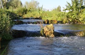
There is a fish bypass channel for upstream migration at every HPP. The bypass channel at HPP Deisenhausen has a flow of 500 l/s and is 500 m long. All other fish bypass channels have a flow of 300 l/s and a length of 130 – 180 m. All fish bypass channels are built as a nature like pond system. The first 10 m of every fish bypass channel is built as a technical vertical slot pass to ensure a more or less consistent water flow. In every fish bypass channel there is furthermore a fish counting pool to register all (upward) migrating fish. This research study is done by Thomas Lechner (IBF Umwelt).
E-flow
The Test Case HPPs at the Günz are run-of river and diversion HPPs. The mean flow runs over the basin Oberegg, there is no hydropeaking. The old river called “Alte Günz” is used as a flood channel. The e-flow is 500 l/s at all time, which is the natural minimum water flow. This is the e-flow the authorities specified.
Research objectives and tasks
This section of the Günz is strongly morphologic downgraded and channelized. The morphologic improvement of the Günz itself is difficult because of the closeness to the settlements and no available areas. Therefore, compensation habitats especially as spawning habitats and habitat for reophile fish species are being investigated to upgrade the ecology of strongly channelized rivers. Based on the findings, compensation habitats in the fish passes will be build.
Research tasks
The research tasks and field studies conducted at the HPPs on the river Günz are:
- Potential scenario modelling
- Potential test of CIA tools
- Management, monitoring and construction of spawning habitats in fishway
- Numerical simulations of flow and habitat conditions in the fishway
Results
In February 2018 and 2019, gravel was implemented as a spawning ground in 4 of the 5 fish passes of LEW Wasserkraft at the river Günz. Afterwards the spawning activities were monitored on a daily basis. A special focus was put on the nase (Chondrostoma nasus), which was very common in former times in the Günz, like in the “barb region” of most rivers in Bavaria.
The nase was selected as a success indicator for the design of the spawning grounds, because their spawning activities depend on the water temperature.
In 2018 the successful spawning of the nase could be verified at the fish pass in Wattenweiler all over the area, where new gravel was implemented. Many eggs were found in that section, just a view days after the gravel was inserted. In the other fish passes downstream, no eggs were found in that year. This was probably because the spawning season of the nase was very early in spring 2018 and the adding of gravel happened too late for that. In 2019 spawning nase were found in all fish passes with ponds with new gravel, but also in ponds where the gravel from the first year was mechanically re-allocated. While the coarse substrates of the initial situation were also used for spawning (nase and dace (Leuciscus leuciscus), the numbers showed that the nase clearly prefers the ponds with new gravel.
The gravel ponds, prepared in 2018, had a relatively strong grade of colmation in 2019, which means that the gaps between the gravel was filled with fine sediments. However, the gravel still was still loose enough for the fish to re-allocate it when preparing their spawning pits. The colmation of the substrate is caused by the static water flow from the main river, which is common in all fish passes. A natural dynamic, in terms of a re-allocation of the bed load, is missing. As the fish were found to prefer new, clean gravel, this results in an expected very good functioning of the new spawning grounds for about two year.
A recommendation from these findings is therefore to include the option to “irrigate” the ponds, when planning the construction of a new fish pass. This could be achieved, for example, with additional pipes that cross the dam. They offer the opportunity to multiplicate the water flow temporarily, enabling a certain nature-like dynamic with a re-allocation of the substrates.
To conclude, the preparation of spawning grounds in existing fish passes by inserting gravel, was a great success, also in terms of a good cost-benefit-ratio.
